hillcountry.ai/field guides The Digital Front Door to the Texas Hill Country
Field Guide · The Hill Country Map

Where does the Texas
Hill Country begin?

Wine labels, tourism maps and Wikipedia all draw it differently. So we asked the land, using four sources: three federal maps and a measurement of how hilly the ground really is. Look up any of 72 towns and see where it lands.

The short version

It starts with water.

Long before anyone drew a line around the Hill Country, the rivers were already drawing it.

For millions of years, the Guadalupe, the Medina, the Frio, the Pedernales and their neighbors have cut down into a high plateau of limestone, while rain soaking into the rock dissolved it from the inside. Where the water cut deep, we call it the Hill Country. Where it hasn’t, the land is still flat.

1The map in circulation

This started with a map in our Facebook group. We used the most official-looking Hill Country map we could find, because it was a federally registered boundary. Our members noticed something was off.

They were right. It isn’t a map of the Hill Country at all. It’s a wine label: the 1991 “Texas Hill Country” wine area, which decides which wines can put that name on the bottle. Its edge follows highways, not hills. The red patches near Fredericksburg are smaller wine areas inside it.
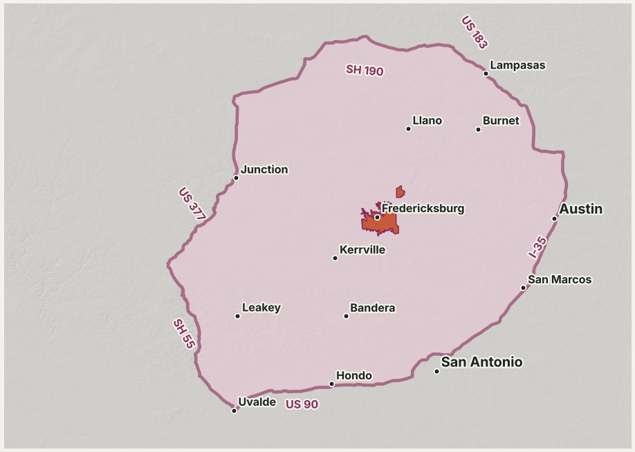
The federal “Texas Hill Country” wine areaIts edge runs along US 183, SH 190, US 377, SH 55, US 90 and I-35.
Map of the Texas Hill Country wine area, outlined along highways

2Every map says something different

Search Google and its AI summary shows a Hill Country that runs from the Pecos River almost to Waco, taking in Temple along the way. It’s the Texas Parks & Wildlife travel region, drawn on county lines for tourism.

Wikipedia’s Hill Country article shows a different one: a green shape a volunteer editor painted in 2010, with no source. It skips most of the granite country around Llano and runs south to the Rio Grande at Del Rio.
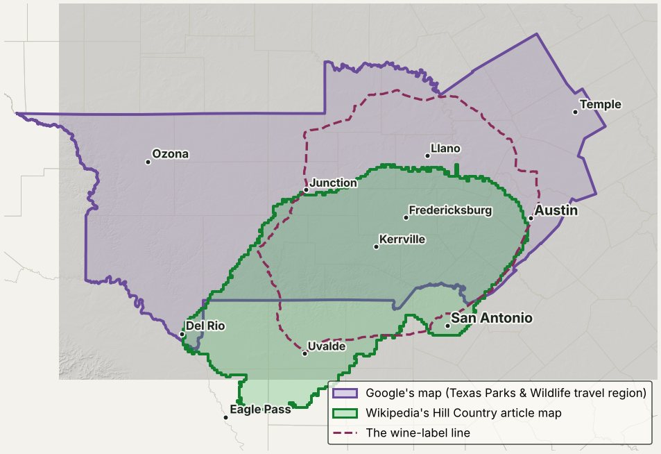
Three Hill Country maps people find firstGoogle’s (purple), Wikipedia’s article map (green) and the wine-label line (dashed). Google’s map reaches Temple. Wikipedia’s reaches Mexico.
Google's Hill Country map, Wikipedia's article map and the wine-label line drawn over Central Texas

Those aren’t the only ones. Texas agencies draw their own Hill Country regions for groundwater law, heritage tourism, travel and wine labels. No two match.

In 2014, a project for Austin Community College geography professor Don Jonsson tried to settle it. It stacked Hill Country maps from 100 sources, from agencies and tourism companies to realtors, to see where they agree. The heart landed near Luckenbach.
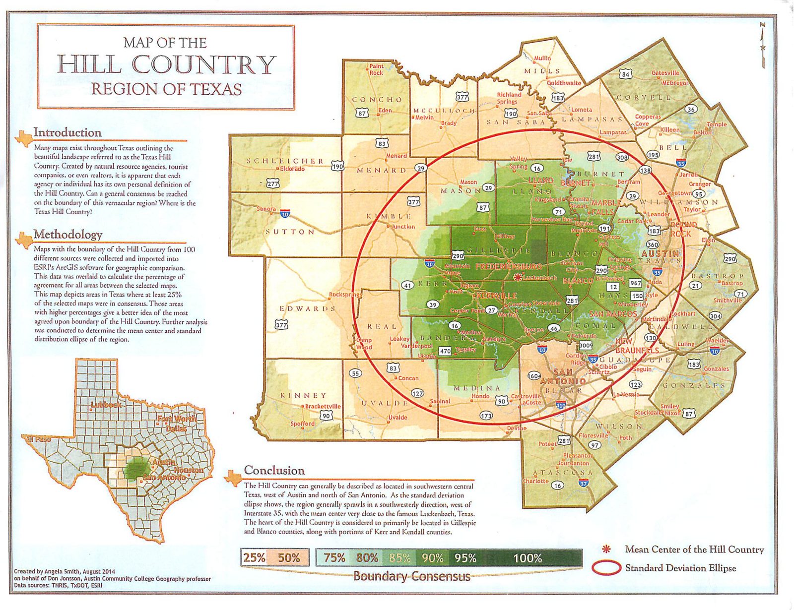
100 Hill Country maps, stackedThe darker the green, the more of the 100 maps agree. Made by Angela Smith for Professor Don Jonsson, Austin Community College, 2014.
Austin Community College map stacking 100 Hill Country maps, darkest in Gillespie and Blanco counties

Those maps show where people say the Hill Country is. We wanted to know what the land says.

3So we asked the land

We gathered maps made by government scientists who have nothing to sell, added our own measurement of the ground, and laid them on top of each other. These are the four sources:

  • APlant and wildlife regions, drawn by the U.S. Environmental Protection Agency
  • BSoil and land regions, drawn by the U.S. Department of Agriculture for farmers and ranchers
  • CLandform regions, drawn by the U.S. Geological Survey from the shape of the land
  • DHow hilly the ground is, measured by us from the U.S. Geological Survey’s elevation map
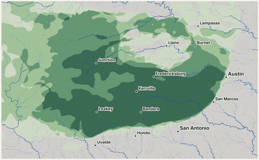
The darker the green, the more of the four sources agree the land is Hill Country
Map shaded darker where more government sources agree

4The rivers drew it

Now look at the rivers and creeks alone, traced from that same elevation map. The hilliest country sits right where the rivers have carved deepest, from the canyons west of Bandera to the bluffs above the Guadalupe and the Pedernales.

The state’s water agency says it plainly. In a 2011 report, it describes the Hill Country as land “formed by the headward erosion of major streams.” In plain words: rivers cut it.
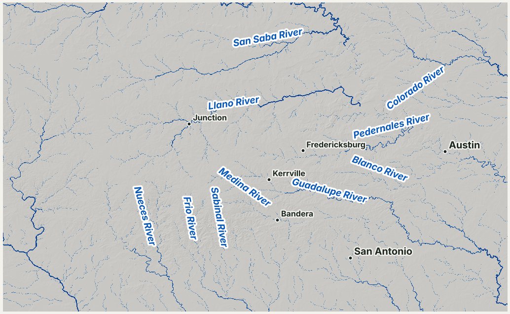
The rivers and creeks of the Hill CountryTraced by computer from U.S. Geological Survey elevation data.
Map of the rivers and creeks of the Hill Country

5Where the rivers haven’t reached

West of Kerrville, around Harper, is a high, flat stretch between the Guadalupe and the Llano. No big river has cut into it yet. So the land stays flat, and the hills stop.

It fits the pattern. Where the water carved, it’s Hill Country. Where it hasn’t, the land stays flat.
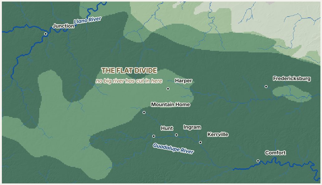
The flat divide around HarperThe pale patch is high, level ground the rivers haven’t reached yet.
Close-up map of the flat divide around Harper, west of Kerrville

6Where the rivers dug deepest

Around Llano, Mason and Enchanted Rock, erosion stripped the limestone away and exposed granite more than a billion years old. It’s different country, ringed by limestone hills on every side.

We call it Llano granite country, and count it as Hill Country with its own label.
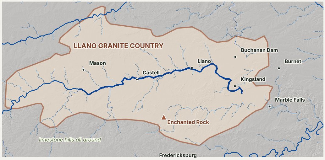
Llano granite countryAround Llano, Mason and Enchanted Rock.
Map of the Llano granite basin and Enchanted Rock

7Our answer

Put it together and you get this map. Dark green is Hill Country. Light green is the Hill Country edge, where the hills fade out. Llano granite country sits in the middle. Gateway towns sit just outside, with the hills on their horizon. Each town’s dot is colored by its label.

The dashed line is the wine map we started with. Notice how much farther it reaches, especially north of Austin and south along US 90.
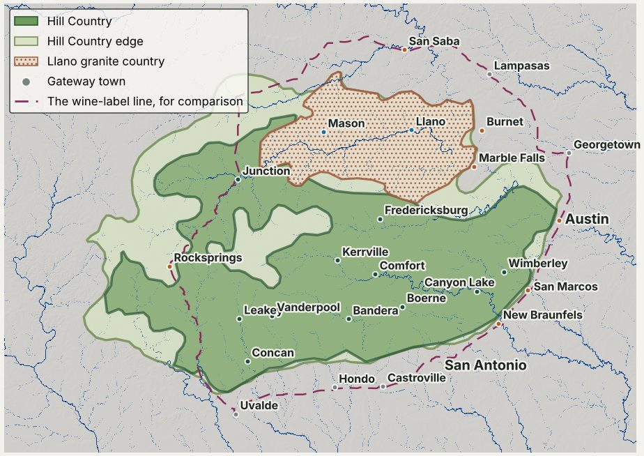
The Hill Country as the land draws itWith the wine-label line dashed, for comparison.
Final map of Hill Country, Hill Country edge, Llano granite country and gateway towns

This is our research, not an official boundary. State geologists sketched a Hill Country region from the land back in the 1970s, and agencies have drawn others since for water, wine and tourism. None of them match. Every source we used is listed at the bottom of this page, and every piece can be checked. We used AI tools to help gather the sources and run the map analysis, all from public data.

8So who decides?

In 1902, Robert T. Hill and T. Wayland Vaughan of the U.S. Geological Survey published their survey of the country around Austin. Hill is often called the father of Texas geology. They noted that the country west of the Balcones Escarpment, the long ridge where the hills meet the plains, was “locally known as ‘the mountains.’” They didn’t need a map. They knew where the hills began because they lived on them.

So who decides what the Hill Country is: the rivers that carved it, or the people who love it?

Interactive map

Look up your town, test the sources

Type a town, flip the layers, drag the hilliness cutoff, and compare the wine-label, Google and Wikipedia maps against what the land says. Every town card links to that town’s page and the places to stay nearby.

All 72 towns

Is your town in the Hill Country?

Every town we scored, by HillCountry.ai region. The label comes from the land within three miles of town, using the standard settings in the map above.

Hill Country · 42Hill Country edge · 14Llano granite country · 7Gateway town · 9

Comal Country

Cowboy Country

Frio Canyon

German Hill Country

Guadalupe Highlands

Highland Lakes

Lake Travis

Llano River Country

Southern Hill Country

Texas Wine Country

Wimberley & the Springs

Outside our regions

  • AustinHill Country edge
  • GeorgetownGateway town
  • LampasasGateway town
  • San AntonioGateway town
Quick answers

Texas Hill Country questions

Where is the Texas Hill Country?

West of Austin and north of San Antonio, where rivers have carved the southeast edge of the Edwards Plateau into hills and canyons. Its sharp eastern and southern edge is the Balcones Escarpment, along I-35 and the US 90 corridor. To the west and north it fades out more slowly, into flat plateau and the granite country around Llano.

What counties are in the Texas Hill Country?

There is no single official list. By the land, more than half of Bandera, Kendall, Real, Comal, Kimble, Gillespie, Hays, Kerr and Blanco counties falls where all four of our sources agree. Edwards, Uvalde, Travis, Bexar and Medina counties are partly in. Llano and Mason counties are Llano granite country, ringed by the hills.

Is there an official Hill Country map?

There are several, and none of them match. A 1991 federal wine area sets which wines can say “Texas Hill Country” on the label. A 1990 state groundwater area covers five counties and parts of four more. State tourism and historical agencies draw their own regions on county lines. Geologists sketched one from the land in the 1970s, but no agency uses it as a boundary.

Is San Antonio in the Hill Country?

Not downtown. San Antonio sits on the plain below the Balcones Escarpment, so we call it a gateway town. Its north side climbs into the hills, and towns like Helotes are Hill Country.

Is Austin in the Hill Country?

Half of it. The Balcones Escarpment runs right through the city: west Austin is hills and canyons, east Austin is prairie. We label Austin the Hill Country edge.

Is my town in the Hill Country?

Use the town lookup in the map above, or find your town in the list below. Every one of our 72 towns has a label: Hill Country, Hill Country edge, Llano granite country or gateway town.

Keep exploring

Follow the rivers that drew it

The Hill Country is river country. Here is where to go next.

Sources

Where every map comes from

This is a research interpretation, not an official boundary. Every source is public, and every number can be checked.

  1. U.S. EPA, Level III and IV Ecoregions of Texas, shapefile downloaded and processed 1 Nov 2026.
  2. USDA NRCS, Major Land Resource Areas, 2022 v5.2, shapefile downloaded and processed.
  3. USGS, Physiographic Divisions of the Conterminous U.S., shapefile downloaded and processed.
  4. USGS 3D Elevation Program, 1 arc-second DEM, 18 tiles covering 29–32° N, 96–102° W.
  5. Jones, I., Anaya, R. and Wade, S., Groundwater Availability Model: Hill Country Portion of the Trinity Aquifer of Texas, TWDB Report 377 (2011), section 3.1 and figure 3-7.
  6. Texas Water Development Board, GIS data: major aquifers and major rivers, downloaded and processed 1 Nov 2026.
  7. 27 CFR 9.136, Texas Hill Country viticultural area (established 1991), boundary from the UC Davis Library AVA project.
  8. Smith, A., for Don Jonsson (Austin Community College), Map of the Hill Country Region of Texas (2014).
  9. Hill, R.T. and Vaughan, T.W., Description of the Austin Quadrangle, USGS Geologic Folio 76.
  10. Texas Bureau of Economic Geology, Physiographic Map of Texas (1996), cited in the AI reviews.
  11. Texas State Historical Association, Handbook of Texas: Hill Country, cited in the AI reviews.
  12. TCEQ and TWDB, Hill Country Priority Groundwater Management Area Update (2010).
  13. Texas Historical Commission, Texas Heritage Trails county list by region.
  14. Fort Hood Sentinel, What counties constitute the Texas Hill Country? (2010), citing Texas Parks & Wildlife, and TPWD, Regional Divisions for Travel and Tourism Planning (2015).
  15. Hill Country Alliance, Strategic Plan 2022–2026.
  16. Wikimedia Commons, 656px-Texas Hill Country Map.png, the map on Wikipedia’s Texas Hill Country article.
  17. U.S. Census Bureau, 2023 county boundaries and TIGER/Line roads.
Write one with us

We build field guides with people who know the Hill Country

River guides, birders, ranchers, historians: if you know a corner of the Hill Country inside out, we’d like to hear your idea. We work with you to turn it into a guide like this one, credited to you or kept anonymous, your choice.

Share your idea →